Hi, I'm Steve. Let's walk that extra mile.ආයුබෝවන්, මම ස්ටීව්. තව සැතපුමක් ඇවිදිමු.
Inspired by the spirit of the lone elephant, my trail name reflects my choice to walk a different path through the wilderness. Here, you’ll find trail reports and personal stories from my journey from a career in law to life in the outdoors.
23Trail reportsමාර්ග වාර්තා
4Countriesරටවල්
1Bookපොත
3,073km on Te Araroaටෙ අරරෝවා කි.මී.
About Steveස්ටීව් ගැන
The courage to change direction
Born in Sri Lanka, the Pearl of the Indian Ocean, I moved to Canada ten years ago, leaving behind a career in law. After working various jobs, I discovered a deep passion for the outdoors, walking long-distance trails from the East Coast all the way to the West. In 2025, I completed the Canadian Outdoor Leadership Training (COLT) program on Vancouver Island, officially stepping into the outdoor industry as a professional.
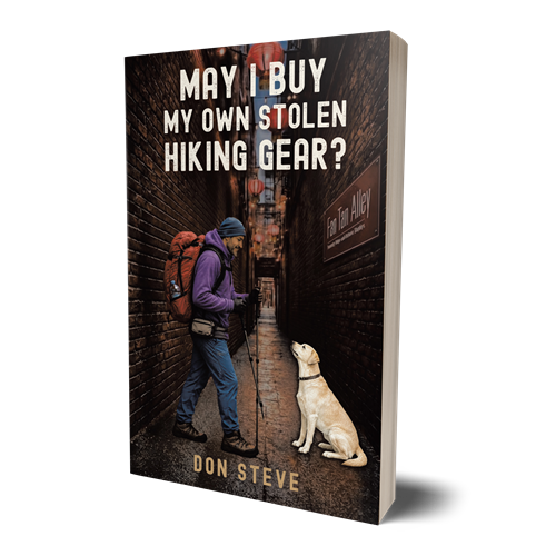
I am the author of the memoir May I Buy My Own Stolen Hiking Gear?, written after losing over $5,000 worth of gear to theft.
Through my blog and writing, I take you deep into the Canadian wilderness and global travels, but more importantly, into the journey within. Every path I walk is about learning to live entirely in the present moment.
Whether you are a fellow hiker drawn to the backcountry, a fan of true wilderness stories, or someone seeking the strength to navigate life when it doesn't follow the map, you’ve found the right place. I’m Don Steve: an outdoor instructor, long-distance backpacker, and author who believes life is defined by the courage to change direction.
Every route written up properly, so you can walk it yourself, or come along with me.සෑම මාර්ගයක්ම නිවැරදිව ලියා ඇත, ඔබටම ඇවිදීමට හෝ මා සමඟ එක්වීමට.
Photosඡායාරූප
Out thereඑළිමහනේ
From the Rockies to Hudson Bay, and the road that led to Te Araroa.රොකී කඳුකරයේ සිට හඩ්සන් බොක්ක දක්වා, සහ ටෙ අරරෝවා දක්වා ගිය මාවත.
Thru-hike · 9 sectionsදිගු කඳු ගමන · කොටස් 9
The long walkදිගු ගමන
Solo thru-hikeතනි දිගු ගමන
Te Araroa, Cape Reinga to Bluffටෙ අරරෝවා, කේප් රේන්ගා සිට බ්ලෆ්
My expedition across the 3,073 km length of New Zealand, shared in one long read featuring photos and maps. Stories go live straight from the trail whenever I'm online. Join my walk.නවසීලන්තයේ කි.මී. 3,073ක දිග පුරා මගේ ගමන, ඡායාරූප සහ සිතියම් සමඟ එක් දිගු ලිපියක. මා අන්තර්ජාලයට සම්බන්ධ වූ සෑම විටම කතා මාවතේ සිටම පළ වේ. මගේ ගමනට එක්වන්න.
Every day of Te Araroa as it happens: photos and notes sent from my phone whenever there's signal, my place on the trail map, and the finished trail report in the same place when I'm home.ටෙ අරරෝවා ගමනේ සෑම දිනයක්ම සිදු වන විටම: සංඥා ඇති විට දුරකථනයෙන් එවන ඡායාරූප සහ සටහන්, සිතියමේ මා සිටින තැන, සහ ගෙදර ආ පසු සම්පූර්ණ මාර්ග වාර්තාව එකම තැන.
Supportසහාය
Buy me a coffeeමට කෝපි එකක් ගෙන දෙන්න
Every coffee keeps the trail reports and the Sinhala navigation lessons free to read.පරිත්යාග යනු ත්යාග මිස චාරිකා වෙන්කිරීම් නොවේ.
Buy Steve a coffeeස්ටීව්ට කෝපි එකක්Keeps the trail reports coming and the Sinhala navigation course free to read.මාර්ග වාර්තා සහ සිංහල මං සෙවීමේ පාඩම් නොමිලේ තබා ගැනීමට.
You add your name and message on Buy Me a Coffee, so nothing is retyped here.ඔබේ නම සහ පණිවිඩය Buy Me a Coffee හි එක් කරන්න. පරිත්යාග යනු ත්යාග මිස චාරිකා වෙන්කිරීම් නොවේ.
Trail letters from Steve, once a monthස්ටීව්ගෙන් මසකට වරක් කඳු ලිපියක්
New articles, tour dates and gear notes. No spam, unsubscribe any time.නව ලිපි, චාරිකා දින සහ උපකරණ සටහන්. ඕනෑම වේලාවක ඉවත් විය හැක.
Contactසම්බන්ධ වන්න
Send me a messageමට පණිවිඩයක් එවන්න
Trip planning, talks, partnerships or just a hello: it all comes here. I reply within a few days.චාරිකා ප්රශ්න, ගමන් සැලසුම්, දේශන සහ හවුල්කාරිත්වය සියල්ල මෙතැනින්. දින කිහිපයක් ඇතුළත පිළිතුරු දෙමි.
Write to Steveස්ටීව්ට ලියන්න
Academia Avenue · Our schoolඅපේ ඉස්කෝලේ
Journalලිපි
Navigation, gear, safety and stories from the trail. Written in Sinhala and English.මං සෙවීම, උපකරණ, ආරක්ෂාව සහ කඳු මාවතේ කතා. සිංහලෙන් සහ ඉංග්රීසියෙන්.
Navigation skills · Lettersමං සෙවුම · ලිපි
The compass: do we really need one in Sri Lanka?මාලිමාව: ලංකාවේ අපිට මාලිමාවක් අවශ්යද?
A simple introduction to the compass, its main parts, and what to look for when you buy your first one.මාලිමාවට සරල හැඳින්වීමක් සමඟ, එහි ප්රධාන කොටස් සහ මාලිමාවක් මිලදී ගැනීමේදී වැදගත් වන කරුණු.
Steve Jayathilaka·2024-03-24·Updated 2026-10-01යාවත්කාලීන කළේ 2026-10-01·6 min readමිනිත්තු 6ක කියවීමක්
Read in
Most popular trails in Sri Lanka are well worn, signposted and busy on weekends. So why carry a compass at all?ලංකාවේ ජනප්රිය කඳු මාර්ග බොහොමයක් හොඳින් පෑගුණු, සලකුණු කළ, සති අන්තවල සෙනඟ පිරුණු ඒවා. එහෙනම් මාලිමාවක් රැගෙන යන්නේ ඇයි?
Because the trail you know in January is not the trail you meet in October. Mist rolls over the Horton Plains grassland in minutes, monsoon rain washes out paths in the Knuckles, and a phone battery rarely survives a cold night. A baseplate compass weighs about 30 grams and never needs charging.ජනවාරියේ ඔබ දන්නා මාර්ගය ඔක්තෝබරයේ එලෙසම නොතිබෙන නිසා. හෝර්ටන් තැන්නට මීදුම විනාඩි කිහිපයකින් ගලා එනවා, මෝසම් වැසි නකල්ස් කඳුවැටියේ මාර්ග සෝදා හරිනවා, සීතල රාත්රියකින් පසු දුරකථන බැටරිය ඉතිරි වෙන්නේ කලාතුරකින්. බේස්ප්ලේට් මාලිමාවක බර ග්රෑම් 30ක් පමණයි, එය කිසිදා ආරෝපණය කරන්න අවශ්ය නැහැ.
The main partsප්රධාන කොටස්
Direction-of-travel arrowගමන් දිශා ඊතලය
Rotating bezel, 0–360° in 2° stepsකරකැවෙන බෙසලය, අංශක 0–360
Magnetic needle, red end points northචුම්බක කටුව, රතු කෙළවර උතුරට
Orienting linesදිශානති රේඛා
Ruler for measuring on a mapසිතියමේ මැනීමට රූලක්
Fig. 1 · A baseplate compass. Drawn diagram, stored as an SVG next to the article.රූපය 1 · බේස්ප්ලේට් මාලිමාවක්.Video · the same compass, used on a real ridge. Plays from YouTube.වීඩියෝව · එම මාලිමාවම සැබෑ කඳු මුදුනක. YouTube වෙතින්.
Read moreතවත් කියවන්න
What to look for when buyingමිලදී ගැනීමේදී බලන්න
A liquid-filled capsule, a bezel marked in 2° steps, a clear baseplate with a ruler, and adjustable declination if you plan to hike abroad. In Sri Lanka declination is close to zero (about 2° west). In the Canadian Rockies it is around 13° east, so there it matters a lot.දියරයෙන් පිරුණු කැප්සියුලයක්, අංශක 2න් 2ට ලකුණු කළ බෙසලයක්, රූල ලකුණු සහිත විනිවිද පෙනෙන පාදමක්, සහ විදේශගත කඳු නැගීමට නම් සකස් කළ හැකි declination එකක්. ලංකාවේ declination අගය ශුන්යයට ආසන්නයි (බටහිරට අංශක 2ක් පමණ). කැනේඩියානු රොකී කඳුකරයේ එය නැගෙනහිරට අංශක 13ක් පමණ නිසා එහිදී එය ඉතා වැදගත්.
Want help planning your hike?ඔබේ ගමන සැලසුම් කිරීමට උදව් අවශ්යද?
Book a 45-minute call. We'll pick the route, the season and the gear together.මිනිත්තු 45ක ඇමතුමක් වෙන් කරන්න. මාර්ගය, කාලය සහ උපකරණ එකට තෝරමු.
Steve Jayathilaka
Outdoor instructor, long-distance backpacker and author. Left a career in law in Sri Lanka for a life outdoors in Canada.තනි කඳු නගින්නෙක් සහ කතුවරයෙක්. ශ්රී ලංකාවේ කඳුකරයේ ඇවිදිමින් හැදී වැඩුණු අතර දැන් කැනඩාවේ සිට කඳු නගියි.
Hikes I have done on my own, written up so you can do them too: distance, water, permits, hazards, the way out, and the GPX track.මා තනිවම කළ කඳු නැගීම්, ඔබටත් කළ හැකි වන ලෙස ලියා ඇත: දුර, ජලය, බලපත්ර, අවදානම්, ඉවත් වීමේ මාර්ග සහ GPX මාර්ගය.
White Mountains · New Hampshire · USA
Presidential Traverse in one dayප්රෙසිඩෙන්ෂියල් ට්රැවර්ස්, එක දිනකින්
Soloතනිවම·Steve Jayathilaka·12 min readමිනිත්තු 12ක කියවීමක්
Distanceදුර37 km 23 mi
Elevation gainනැගීම+2,700 m 8,900 ft
High pointඋසම ස්ථානය1,917 m Mt Washington
Time takenගත වූ කාලය14 h 20 min
Routeමාර්ග වර්ගයPoint to pointඑක් තැනක සිට තවත් තැනකට
Difficultyදුෂ්කරතාවExpertප්රවීණ
Best seasonහොඳම කාලයLate Jun – Sepජූනි අග – සැප්.
Hikedඇවිද්ද දිනය2026-09-06
Trailheadsආරම්භය / අවසානය
Start: Appalachia, Route 2 · ආරම්භය: Appalachia, Route 2 · 44.371° N 71.289° W Finish: Crawford Notch · අවසානය: Crawford Notch · 44.218° N 71.411° W
Permits & feesබලපත්ර සහ ගාස්තු
No permit for a day hike. Parking pass USD 5 a day at both trailheads.දිවා ගමනකට බලපත්රයක් අවශ්ය නැත. ආරම්භ ස්ථාන දෙකේම වාහන නැවැත්වීමට දිනකට USD 5.
Waterජලය
Madison Spring Hut (6 km) and Lakes of the Clouds Hut (17.5 km), summer only. Nothing reliable between them.Madison Spring Hut (කි.මී. 6) සහ Lakes of the Clouds Hut (කි.මී. 17.5), ගිම්හානයේ පමණි. ඒ අතර විශ්වාසදායක ජලය නැත.
Shelterනවාතැන්
AMC huts along the ridge, booked months ahead. No camping above the treeline.කඳු වැටිය දිගේ AMC කුටි, මාස ගණනකට පෙර වෙන් කළ යුතුය. ගස් රේඛාවට ඉහළ කඳවුරු බැඳීම තහනම්.
Phone signalදුරකථන සංඥා
Good on most summits, none in the ravines, weak at Crawford Notch.බොහෝ කඳු මුදුන්වල හොඳයි, මිටියාවත්වල නැත, Crawford Notch හි දුර්වලයි.
Hazards & exitsඅවදානම් සහ ඉවත් වීම
Sudden fog, high wind and cold above the treeline. Check the Mount Washington Observatory higher summits forecast the night before. Exits: Jewell Trail and Ammonoosuc Ravine Trail.ගස් රේඛාවට ඉහළින් හදිසි මීදුම, තද සුළං සහ සීතල. පෙර රාත්රියේ Mount Washington Observatory කාලගුණ අනාවැකිය බලන්න. ඉවත් වීමේ මාර්ග: Jewell Trail සහ Ammonoosuc Ravine Trail.
Routeමාර්ගය
Drawn here as a placeholder. On the real site this is an interactive OpenStreetMap made from the GPX track.මෙය ආදර්ශයකි. සැබෑ වෙබ් අඩවියේ GPX මාර්ගයෙන් සාදන OpenStreetMap සිතියමකි.Elevation profile, built from the same GPX file.එම GPX ගොනුවෙන් සාදන උන්නතාංශ පැතිකඩ.
⚠Conditions change. This report describes the trail on 6 September 2026.තත්ත්වයන් වෙනස් වේ. මෙම වාර්තාව 2026 සැප්තැම්බර් 6 දින මාර්ගයේ තත්ත්වය විස්තර කරයි.
Why solo, and why in one dayතනිවම, එක දිනකින් ඇයි?
The AMC huts were full until October, and the forecast showed one clear, calm day. That settled it. Doing the whole ridge in a day means a light pack and a very long walk, so this report is mostly about pacing, water and when to turn back.AMC කුටි ඔක්තෝබර් දක්වා පිරී තිබුණා, කාලගුණ අනාවැකියේ තිබුණේ පැහැදිලි, සන්සුන් එක් දිනයක් පමණයි. ඒ අනුව තීරණය වුණා. මුළු කඳු වැටියම දිනකින් යාම යනු සැහැල්ලු බෑගයක් සහ ඉතා දිගු ඇවිදීමක්. ඒ නිසා මේ වාර්තාව වැඩිපුරම වේගය, ජලය සහ ආපසු හැරිය යුතු වේලාව ගැනයි.
Valley Way to Madison · 0–6 kmValley Way සිට මැඩිසන් දක්වා · කි.මී. 0–6
I left the Appalachia trailhead at 4:50 a.m. with a headlamp. The Valley Way climbs 1,200 m through forest with no views. It is steady rather than steep. I reached Madison Spring Hut at 7:40 and filled both bottles.උදේ 4:50ට හිස් ලාම්පුවක් සමඟ Appalachia ආරම්භයෙන් පිටත් වුණා. Valley Way මාර්ගය දර්ශන නැති වනාන්තරයක් හරහා මීටර් 1,200ක් නගිනවා. එය බෑවුම් සහිත නොව ස්ථාවර නැගීමක්. 7:40ට Madison Spring Hut වෙත ළඟා වී බෝතල් දෙකම පිරෙව්වා.
Above the treeline on Madison at 8 a.m. From here to Washington there is no shade and no water.උදේ 8ට මැඩිසන් කන්දේ ගස් රේඛාවට ඉහළින්. මෙතැන් සිට වොෂිංටන් දක්වා සෙවණක් හෝ ජලය නැත.
The Northern Presidentials · 6–16 kmඋතුරු ප්රෙසිඩෙන්ෂියල් · කි.මී. 6–16
This is the slow part. The Gulfside Trail is boulder hopping between cairns, and my pace dropped to 2 km an hour. Fog came in over Jefferson for forty minutes. On a ridge like this, following cairns and holding a compass bearing is a real skill you will use.මෙය මන්දගාමී කොටසයි. Gulfside මාර්ගය ගල් ගොඩවල් (cairns) අතර පාෂාණ මතින් පැනීමකි. මගේ වේගය පැයට කි.මී. 2 දක්වා අඩු වුණා. ජෙෆර්සන් කන්ද මතට විනාඩි හතළිහක් මීදුම ආවා. මෙවැනි කඳු වැටියක ගල් ගොඩවල් අනුගමනය කිරීම සහ මාලිමා දිශා කෝණයක් රඳවා ගැනීම ඔබ සැබවින්ම භාවිත කරන කුසලතාවයකි.
Cairns on the Gulfside Trail. In fog you walk from one to the next.Gulfside මාර්ගයේ ගල් ගොඩවල්. මීදුමේදී එකින් එකට ඇවිදිනවා.
Mount Washington · 16 kmවොෂිංටන් කන්ද · කි.මී. 16
The summit has a road, a railway and a café, which feels strange after six hours of rock. It is also the last easy place to bail out. My rule was simple: if I was not on the summit by 1 p.m., I would go down the Ammonoosuc Ravine Trail. I arrived at 12:15.කඳු මුදුනට මාර්ගයක්, දුම්රියක් සහ ආපන ශාලාවක් තිබෙනවා. පැය හයක් පාෂාණ මත ඇවිදීමෙන් පසු එය අමුතු හැඟීමක්. ගමන නවතා බැසීමට පහසුම අවසාන ස්ථානයද එයයි. මගේ නීතිය සරලයි: දහවල් 1 වන විට මුදුනේ නැත්නම් Ammonoosuc Ravine මාර්ගයෙන් පහළට. මම 12:15ට ළඟා වුණා.
Video · wind check and the turnaround decision on the summit.වීඩියෝව · කඳු මුදුනේ සුළඟ සහ ආපසු හැරීමේ තීරණය.
Down the Southern Presidentials · 16–37 kmදකුණු ප්රෙසිඩෙන්ෂියල් දිගේ පහළට · කි.මී. 16–37
The Crawford Path, first cut in 1819, is smoother and mostly downhill. The last 8 km below Jackson felt like the longest of the day. I reached Crawford Notch at 7:10 p.m., 14 hours 20 minutes after starting.1819 දී පළමුවරට කැපූ Crawford Path වඩා සුමට, බොහෝ දුරට බැස්මකි. ජැක්සන් කන්දට පහළ අවසාන කි.මී. 8 දවසේ දිගම කොටස ලෙස දැනුණා. ආරම්භ කර පැය 14යි විනාඩි 20කට පසු, සවස 7:10ට Crawford Notch වෙත ළඟා වුණා.
Evening light on the Crawford Path below Mount Pierce.පියර්ස් කන්දට පහළ Crawford Path හි සවස ආලෝකය.
What I carriedරැගෙන ගිය දේ
Trail runners, not bootsසපත්තු වෙනුවට trail runners
Rain shell and fleeceවැසි කබාය සහ fleece
Warm hat and gloves, even in Septemberඋණුසුම් තොප්පිය සහ අත්වැසුම්, සැප්තැම්බරයේ වුවද
2 L of water and a filter †ජලය ලීටර් 2 සහ පෙරනයක් †
Headlamp and spare batteryහිස් ලාම්පුව සහ අමතර බැටරිය
Paper map and baseplate compass †කඩදාසි සිතියම සහ මාලිමාව †
Pack weight 6.8 kg with water. † affiliate link: the site earns a small commission.ජලය සමඟ බෑගයේ බර කි.ග්රෑ. 6.8. † අනුබද්ධ සබැඳිය.
What it costවියදම
Parking passවාහන නැවැත්වීම
USD 5
Taxi back to the startආරම්භයට ආපසු ටැක්සිය
USD 75
Trail foodආහාර
USD 28
Totalඑකතුව
USD 108
Point to point means a second car or a taxi. Book the taxi the day before.ආරම්භය සහ අවසානය වෙනස් නිසා දෙවන වාහනයක් හෝ ටැක්සියක් අවශ්යයි. පෙර දින වෙන් කරන්න.
What I'd do differentlyනැවත කරන්නේ නම් වෙනස් කරන දේ
Start at 4 a.m. to keep more daylight in reserve.වැඩි දිවා ආලෝකයක් ඉතිරි කර ගැනීමට උදේ 4ට පටන් ගන්න.
Carry 3 L from Madison Spring Hut, not 2.Madison Spring Hut සිට ලීටර් 2 නොව 3ක් රැගෙන යන්න.
Eat every hour on the Northern Presidentials, even when not hungry.බඩගිනි නැති වුවද, උතුරු කොටසේදී පැයෙන් පැය කන්න.
Want to do a hike like this with company?මෙවැනි කඳු නැගීමක් කණ්ඩායමක් සමඟ කරන්න කැමතිද?
Before you go, read lesson 4: Walking a bearing.යාමට පෙර 4 වන පාඩම කියවන්න: දිශා කෝණයක් ඔස්සේ ඇවිදීම.
Steve Jayathilaka
Outdoor instructor, long-distance backpacker and author. Left a career in law in Sri Lanka for a life outdoors in Canada.තනි කඳු නගින්නෙක් සහ කතුවරයෙක්. ශ්රී ලංකාවේ කඳුකරයේ ඇවිදිමින් හැදී වැඩුණු අතර දැන් කැනඩාවේ සිට කඳු නගියි.
Multi-night hikes and backcountry camps, led in person. Difficulty is shown as trail blazes, from one (easy) to four (expert).පුද්ගලිකව මෙහෙයවන රාත්රී කිහිපයක කඳු නැගීම් සහ කඳවුරු. දුෂ්කරතාවය සලකුණු 1 (පහසු) සිට 4 (ප්රවීණ) දක්වා.
Past tripsපසුගිය චාරිකා
Banff National Park · Alberta · Canada
3 nights in the Rockies backcountryරොකී කඳුකරයේ රාත්රී 3ක කඳවුරු චාරිකාව
Nightsරාත්රී3
Difficultyදුෂ්කරතාවChallengingඅභියෝගාත්මක
SeasonකාලයJul – Sepජූලි – සැප්.
Groupකණ්ඩායමMax 8උපරිම 8
Distanceදුර45 km · +1,940 m
The tripචාරිකාව
Four days on foot through larch forest, alpine lakes and one high pass. We carry everything, camp at designated backcountry sites, and practise real navigation along the way. You need to be comfortable walking 12 km a day with a 15 kg pack.ලාර්ච් වනාන්තර, ඇල්පයින් විල් සහ උස් කඳු මංසන්ධියක් හරහා පයින් දින හතරක්. අවශ්ය සියල්ල රැගෙන, නියමිත කඳවුරු ස්ථානවල නවාතැන් ගෙන, මඟදී සැබෑ මං සෙවීම පුහුණු වෙමු. කිලෝ 15ක බෑගයක් සමඟ දිනකට කි.මී. 12ක් ඇවිදීමට හැකි විය යුතුය.
Day by dayදිනෙන් දින
Day 1 · Trailhead to the lake camp1 වන දිනය · ආරම්භයේ සිට විල අසල කඳවුරට
11 km · +540 m · 4–5 h
Gear check at the trailhead, then a steady climb through forest to camp by the water.ආරම්භයේදී උපකරණ පරීක්ෂාව, පසුව වනාන්තරය හරහා විල අසල කඳවුරට.
Light packs. We take bearings off real peaks and correct for 13° east declination.සැහැල්ලු බෑග්. සැබෑ කඳු මුදුන් වෙත දිශා කෝණ ගෙන, නැගෙනහිර අංශක 13ක declination නිවැරදි කරමු.
Day 3 · Over the pass to the meadow camp3 වන දිනය · කඳු මංසන්ධිය හරහා තණබිම් කඳවුරට
13 km · +620 m · 6–7 h
The big day. Early start, the high point of the trip, and a long descent to the meadows.ප්රධාන දිනය. උදෑසනම ආරම්භ කර චාරිකාවේ උසම ස්ථානයට, පසුව තණබිම් වෙත දිගු බැසීමක්.
Day 4 · Out to the trailhead4 වන දිනය · ආපසු ආරම්භයට
12 km · −900 m · 4 h
Downhill most of the way. Back in Banff by mid-afternoon.බොහෝ දුරක් බැස්මකි. දහවල් වන විට බැන්ෆ් වෙත.
What's includedඇතුළත් දේ
Includedඇතුළත්
Parks Canada backcountry permitsParks Canada කඳවුරු බලපත්ර
Stoves, bear canisters, first aidලිප්, ආහාර බඳුන්, ප්රථමාධාර
All meals on the trailමාර්ගයේ සියලු ආහාර
Navigation lessonsමං සෙවීමේ පාඩම්
Not includedඇතුළත් නැත
Travel to Banffබැන්ෆ් දක්වා ගමන
Personal gear and sleeping bagපුද්ගලික උපකරණ සහ නිදන බෑගය
Travel insuranceසංචාරක රක්ෂණය
Photosඡායාරූප
Questionsප්රශ්න
How fit do I need to be?කොතරම් යෝග්යතාවයක් අවශ්යද?
You should be comfortable walking 12 km a day with a 15 kg pack, two days in a row. Train with your loaded pack for a month before.කි.ග්රෑ. 15ක බෑගයක් සමඟ දිනකට කි.මී. 12ක් අඛණ්ඩව දින දෙකක් ඇවිදීමට හැකි විය යුතුය.
Can I join on my own?මට තනිවම එක්විය හැකිද?
Yes. Most guests come alone. Tents are shared with someone of the same gender, or you can pay for a single tent.ඔව්. බොහෝ අමුත්තන් තනිවම පැමිණේ. කූඩාරම් එකම ස්ත්රී පුරුෂ භාවයේ අයෙකු සමඟ බෙදා ගනී.
What happens if the weather is bad?කාලගුණය නරක නම් කුමක් වේද?
We change the route to a safer one in the same area. If the park closes the trail, you get a full refund or a place on another date.එම ප්රදේශයේම ආරක්ෂිත මාර්ගයකට වෙනස් කරමු. මාර්ගය වසා දැමුවහොත් සම්පූර්ණ මුදල හෝ වෙනත් දිනයක් ලැබේ.
What is the cancellation policy?අවලංගු කිරීමේ ප්රතිපත්තිය කුමක්ද?
The deposit is refundable up to 60 days before departure. After that it can move to another tour within a year.පිටත්වීමට දින 60කට පෙර තැන්පතුව ආපසු ලබා ගත හැක.
Do I need my own gear?මගේම උපකරණ අවශ්යද?
You bring personal gear and a sleeping bag. Group gear is included. See the free gear lists in the Market.පුද්ගලික උපකරණ සහ නිදන බෑගය ඔබ ගෙන එයි. කණ්ඩායම් උපකරණ ඇතුළත්.
Don Steve · Steve Jayathilaka
Booksපොත්
Now availableදැන් ලබා ගත හැක
May I Buy My Own Stolen Hiking Gear?
Leaving a legal career for the trails of Canada's East Coast and Vancouver Island, then losing the gear that made it possible. A book about walking on when life doesn't follow the map.නීති වෘත්තිය හැර කැනඩාවේ නැගෙනහිර වෙරළ සහ වැන්කුවර් දූපතේ කඳු මාවත් කරා ගිය ගමන, පසුව එය කළ හැකි කළ උපකරණ අහිමි වීම. ජීවිතය සිතියම අනුව නොයන විට දිගටම ඇවිදීම ගැන පොතක්.
More books will appear here as a grid. Each book is one entry in the control panel with a cover, a blurb and a link to its own website.තවත් පොත් මෙහි පෙන්වනු ඇත.
Guide · Sri Lankaමාර්ගෝපදේශය · ශ්රී ලංකාව
5 best solo hikes in Sri Lankaශ්රී ලංකාවේ තනිවම යා හැකි හොඳම කඳු මාවත් 5
Busy enough to feel safe, quiet enough to feel like yours. These are the trails I'd send a first-time solo hiker to, and the ones I go back to.ආරක්ෂිත යැයි හැඟෙන තරමට ජනාකීර්ණ, ඔබේම යැයි හැඟෙන තරමට නිස්කලංක. තනිවම පළමු වරට යන කෙනෙකුට මා යෝජනා කරන, මා නැවත නැවත යන මාවත්.
Steve Jayathilaka·Updated 2026-10-12යාවත්කාලීන කළේ 2026-10-12·10 min readමිනිත්තු 10ක කියවීමක්
Quick picksඉක්මන් තේරීම්
Best first solo hike:පළමු තනි ගමනට:Horton Plains and World's Endහෝර්ටන් තැන්න සහ ලෝකාන්තය
Best long day:දිගු දිනකට:Kirigalpoththaකිරිගල්පොත්ත
Best sunrise:හොඳම හිරු උදාව:Sri Pada by the Kuruwita routeකුරුවිට මාර්ගයෙන් ශ්රී පාදය
Best multi-day:දින කිහිපයකට:Knuckles Range traverseනකල්ස් කඳුවැටිය හරහා
Quietest:වඩාත් නිස්කලංක:Pitawala Pathana and Riverstonපිටවල පතන සහ රිවර්ස්ටන්
1. Horton Plains and World's Endහෝර්ටන් තැන්න සහ ලෝකාන්තය
9.5 km loop+200 mDec – Marදෙසැ. – මාර්.
Early mist on the plateau. By 10 a.m. the view at World's End is usually gone.තැන්නේ උදෑසන මීදුම. උදේ 10 වන විට ලෝකාන්තයේ දර්ශනය බොහෝ විට නැති වේ.
A loop across the plateau to the cliff at World's End and back past Baker's Falls. The path is busy and well marked, which makes it a good first walk on your own. Be at the gate when it opens at 6 a.m.තැන්න හරහා ලෝකාන්තයේ ප්රපාතය දක්වා ගොස් බේකර්ස් ඇල්ල පසුකර ආපසු එන වට මාර්ගයකි. මාර්ගය හොඳින් සලකුණු කර ඇති අතර සෙනඟ සිටින නිසා තනිවම යන පළමු ගමනට සුදුසුයි. උදේ 6ට දොරටුව විවෘත වන විට එහි සිටින්න.
2. Kirigalpoththaකිරිගල්පොත්ත
14 km return+450 mDec – Marදෙසැ. – මාර්.
The grassland stretch on the way to the summit.මුදුනට යන මඟ තණබිම් කොටස.
The second-highest peak in Sri Lanka and the highest one open to hikers. Most of the walk is easy grassland; the last kilometre is steep, muddy forest. Turn back by 1 p.m. if you are not at the top.ශ්රී ලංකාවේ දෙවන උසම කඳු මුදුන සහ කඳු නගින්නන්ට විවෘත උසම මුදුනයි. වැඩි කොටස පහසු තණබිම්ය; අවසාන කිලෝමීටරය බෑවුම් සහිත මඩ වනාන්තරයකි. දහවල් 1 වන විට මුදුනේ නැත්නම් ආපසු හැරෙන්න.
Read moreතවත් කියවන්න
3. Sri Pada by the Kuruwita routeකුරුවිට මාර්ගයෙන් ශ්රී පාදය
15 km+1,700 mDec – Mayදෙසැ. – මැයි
Sunrise from the summit, worth every one of the steps.මුදුනේ සිට හිරු උදාව, සෑම පඩියකටම වටිනවා.
Most pilgrims take the Hatton route. The Kuruwita route from the Ratnapura side is longer, steeper and much quieter, with forest instead of tea stalls for most of the climb. Start around midnight to reach the top for sunrise.බොහෝ වන්දනාකරුවන් හැටන් මාර්ගයෙන් යති. රත්නපුර පැත්තේ කුරුවිට මාර්ගය දිගු, බෑවුම් සහිත සහ වඩා නිස්කලංකයි. හිරු උදාවට මුදුනට යාමට මධ්යම රාත්රිය පමණ ආරම්භ කරන්න.
Evening over the Knuckles from the night's camp.රාත්රී කඳවුරේ සිට නකල්ස් කඳුවැටියේ සවස.
Cloud forest, ridges and village paths over two days. You need a permit from the Forest Department, and a local guide is strongly recommended because junctions are unmarked.දින දෙකක් තුළ වලාකුළු වනාන්තර, කඳු මුදුන් සහ ගම් මාවත්. වන සංරක්ෂණ දෙපාර්තමේන්තුවේ බලපත්රයක් අවශ්ය වන අතර මංසන්ධි සලකුණු කර නැති නිසා ප්රදේශවාසී මඟපෙන්වන්නෙකු ඉතා නිර්දේශිතයි.
5. Pitawala Pathana and Riverstonපිටවල පතන සහ රිවර්ස්ටන්
6 km+150 mJan – Aprජන. – අප්රේ.
The drop at Pitawala Pathana, the "mini World's End".පිටවල පතනේ ප්රපාතය, "කුඩා ලෝකාන්තය".
A short, windy grassland plateau with a cliff edge of its own. Almost empty on weekdays, which is the point. Combine it with the Riverston viewpoint for a full morning.තමන්ගේම ප්රපාතයක් සහිත කෙටි, සුළං සහිත තණබිම් තැන්නකි. සතියේ දිනවල බොහෝ විට හිස්ය. පූර්ණ උදෑසනකට රිවර්ස්ටන් දර්ශන ස්ථානය සමඟ එකතු කරන්න.
Before you goයාමට පෙර
Start early. Afternoon rain and cloud are normal in the hills.කලින් පටන් ගන්න. කඳුකරයේ දහවල් වැස්ස සහ වලාකුළු සාමාන්යයි.
Leech socks or salt in the wet season.තෙත් කාලයේ කූඩැල්ලන්ට මේස් හෝ ලුණු.
Tell someone your route and when you'll be back.ඔබේ මාර්ගය සහ ආපසු එන වේලාව කෙනෙකුට කියන්න.
Carry cash for park tickets. Card machines are rare at gates.උද්යාන ප්රවේශ පත්ර සඳහා මුදල් රැගෙන යන්න.
Want help planning your hike?ඔබේ ගමන සැලසුම් කිරීමට උදව් අවශ්යද?
Book a 45-minute call. We'll pick the route, the season and the gear together.මිනිත්තු 45ක ඇමතුමක් වෙන් කරන්න. මාර්ගය, කාලය සහ උපකරණ එකට තෝරමු.
Steve Jayathilaka
Outdoor instructor, long-distance backpacker and author. Left a career in law in Sri Lanka for a life outdoors in Canada.තනි කඳු නගින්නෙක් සහ කතුවරයෙක්. ශ්රී ලංකාවේ කඳුකරයේ ඇවිදිමින් හැදී වැඩුණු අතර දැන් කැනඩාවේ සිට කඳු නගියි.
Two course series on finding your way in the hills: one with a compass, one without any instrument at all. Written by Steve Jayathilaka for hikers and back-country campers.
Lead with
2Course series
11Lessons
3Hours in total
FreeTo start, both series
පාඩම් මාලා · Course series
The courses
No prerequisites. Questions are answered in the comments under each lesson.
Titles, lesson codes, durations and the running order come from Steve's published Sinhala series. The English lines are plain-language descriptions, not official translations.
Navigation Skills · මං සෙවුම
Letters between the lessons
Shorter pieces on one idea at a time: reading a compass bezel, tying a useful knot, what to carry. New articles and answers are added over time.
Used gear, maps and printablesපාවිච්චි කළ උපකරණ, සිතියම් සහ මුද්රණ
Marketවෙළඳපොළ
Gear I've carried and no longer need, GPX tracks and maps of my routes, and printable checklists. Used items are one of a kind: once they're sold, they're gone.මා රැගෙන ගිය, දැන් අවශ්ය නැති උපකරණ, මගේ මාර්ගවල GPX සහ සිතියම්, මුද්රණය කළ හැකි ලැයිස්තු. පාවිච්චි කළ භාණ්ඩ එකක් පමණි: විකුණූ පසු නැත.
Payments by Stripe. For used gear I confirm the shipping cost by email before sending; files are emailed straight after payment.ගෙවීම් Stripe හරහා. පාවිච්චි කළ උපකරණ සඳහා යැවීමට පෙර ප්රවාහන ගාස්තුව ඊමේල් මගින් තහවුරු කරමි; ගොනු ගෙවීමෙන් පසු වහාම ඊමේල් කෙරේ.
Free resourcesනොමිලේ සම්පත්
Gear listsඋපකරණ ලැයිස්තු
4.2 kg
Solo day-hike kitතනි දිවා ගමන් කට්ටලය
20 L packලීටර් 20 බෑගය †
Rain shell and warm layerවැසි කබාය සහ උණුසුම් ස්ථරය
Baseplate compass and paper mapමාලිමාව සහ කඩදාසි සිතියම †
Headlamp, whistle, first aidහිස් ලාම්පුව, විසිල, ප්රථමාධාර
Food for 3 days, about 2.4 kgදින 3ක ආහාර, කි.ග්රෑ. 2.4 පමණ
Permits by countryරටවල් අනුව බලපත්ර
Countryරට
Day hikesදිවා ගමන්
Overnightරාත්රී ගමන්
Canadaකැනඩාව
Parks Canada pass in national parksජාතික උද්යානවල Parks Canada බලපත්රය
Backcountry permit and campsite booking, opens in winter for summerකඳවුරු බලපත්රය සහ ස්ථාන වෙන් කිරීම
USA · White Mountainsඇමරිකාව · වයිට් මවුන්ටන්ස්
Parking pass at most trailheadsබොහෝ ආරම්භ ස්ථානවල වාහන බලපත්රය
AMC hut booking; no camping above the treelineAMC කුටි වෙන් කිරීම
Sri Lankaශ්රී ලංකාව
Park ticket at the gate (Horton Plains)දොරටුවේ ප්රවේශ පත්රය (හෝර්ටන් තැන්න)
Forest Department permit for the Knuckles; guide recommendedනකල්ස් සඳහා වන දෙපාර්තමේන්තු බලපත්රය
France · Italy · Switzerlandප්රංශය · ඉතාලිය · ස්විට්සර්ලන්තය
Noneඅවශ්ය නැත
Book refuges months ahead in July and Augustජූලි සහ අගෝස්තුවල මාස ගණනකට පෙර කුටි වෙන් කරන්න
† Affiliate link: the site earns a small commission at no cost to you. Gear provided free by a brand is always marked.† අනුබද්ධ සබැඳිය. නොමිලේ ලැබුණු උපකරණ සෑම විටම සලකුණු කෙරේ.
Done and nextකළ දේ සහ ඊළඟට
The listමගේ ලැයිස්තුව
Trails I've walked and the ones I'm training for. Every ticked one has a trail report.මා ඇවිද ගිය මාවත් සහ මා පුහුණු වන මාවත්. සලකුණු කළ සෑම එකකටම මාර්ග වාර්තාවක් ඇත.
23trails walkedඇවිද ගිය මාවත්
4countriesරටවල්
612km on foot in 20262026 දී පයින් කි.මී.
● walked ○ planned. Placeholder drawing; the real site uses an OpenStreetMap world map.● ඇවිද ගිය ○ සැලසුම් කළ. ආදර්ශ චිත්රයකි.
Walkedඇවිද ගිය
Nextඊළඟට
Credits
Photo credits
Some of the photos on this site are free-licensed images from Wikimedia Commons, used under the licences below and loaded directly from Commons.
Single Elephant · Content panel
Only collaborators on the site's GitHub repository can sign in.
Protected by Cloudflare Access · signed in as client@email
Single Elephant CMSChanges go live about a minute after publishing.
 Steve Jayathilaka·2024-03-24·Updated 2026-10-01යාවත්කාලීන කළේ 2026-10-01·6 min readමිනිත්තු 6ක කියවීමක්